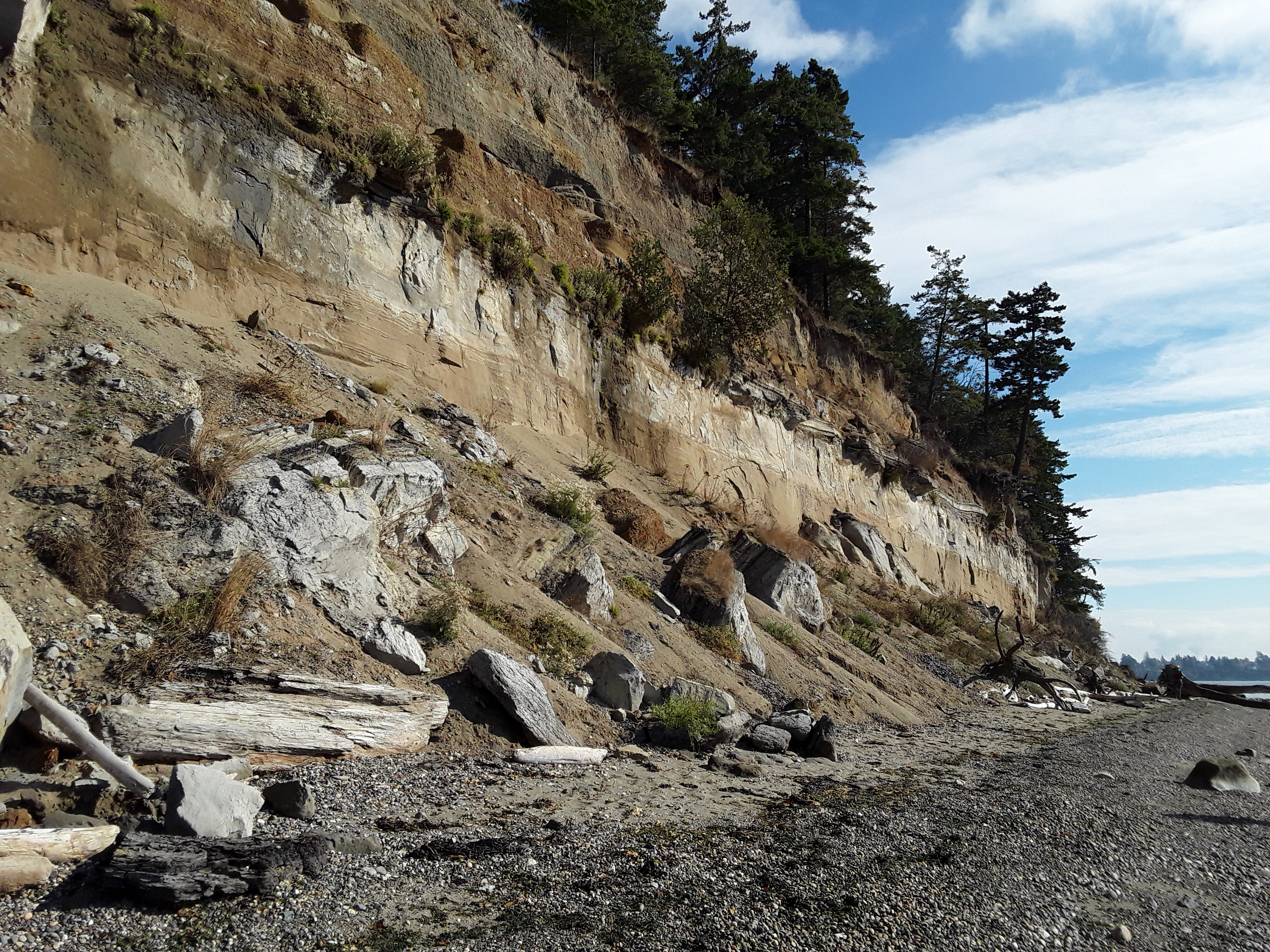
Kelly's Point is one of the most beloved beaches and wildlife areas in the north Puget Sound region. The property includes iconic Yellow Bluff, a view well-known to the ferries and boats entering and leaving Anacortes. Over two million passengers a year ride past these majestic cliffs. Kelly’s Point Conservation Area provides access to over a half-mile long stretch of beach to visitors for scenic walks and bird watching.
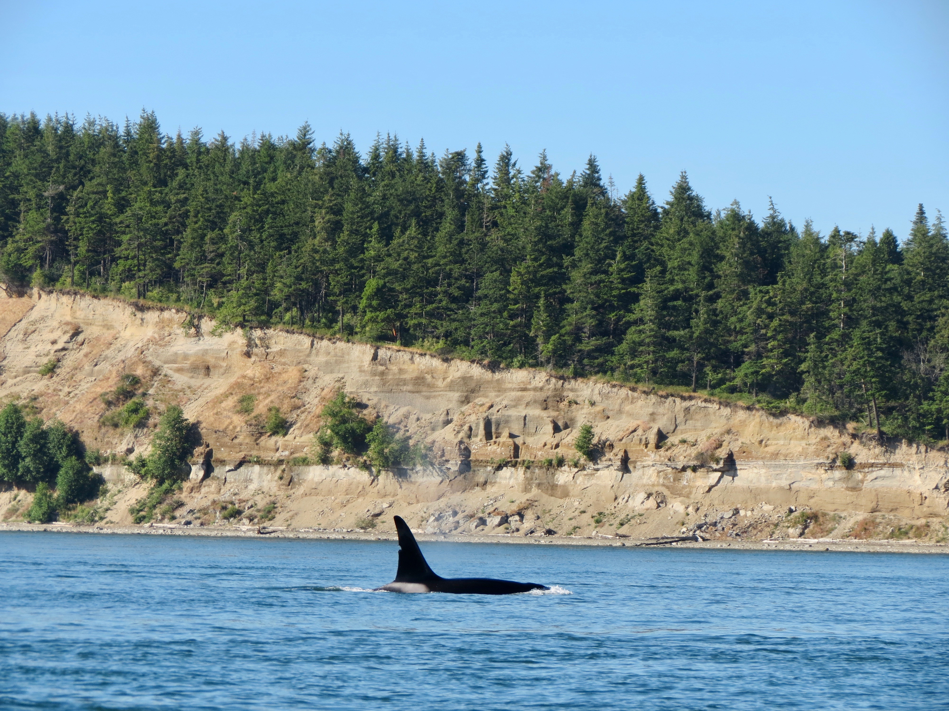
Pictured above: An orca rises in front of Yellow Bluff, part of Kelly's Point Conservation Area. Photograph credit: David Wertheimer.
Kelly's Point Conservation Area protects the cliffs of Yellow Bluff. Yellow Bluff is a "feeder bluff" that feeds sand, mud, pebbles and other sediment to nearby beaches and marine tidelands as it slowly erodes. Yellow Bluff provides beach sediments to both beaches conservation lands on Guemes Island. Sediment from Yellow Bluff sustains wildlife habitat, including at nearby 64-acre Peach Preserve managed by the San Juan Preservation Trust. The sediment anchors marine eelgrass meadows home to surf smelt, mollusks and shrimp. These animals in turn support fish and wildlife habitat including salmon which the Southern Resident Orca whales require.
Conservation Story
The designation of Kelly's Point Conservation Area is a testament to the community's love and support for this unique property. In 2018 Skagit Land Trust purchased the 27 acres and 3,000 feet of shoreline that comprise Kelly's Point Conservation Area.
More than 425 families, organizations and businesses donated to the campaign to conserve Kelly's Point. Almost half of project donors had direct connections to Guemes Island and the majority of donations came from residents of Skagit, Whatcom and Island counties.
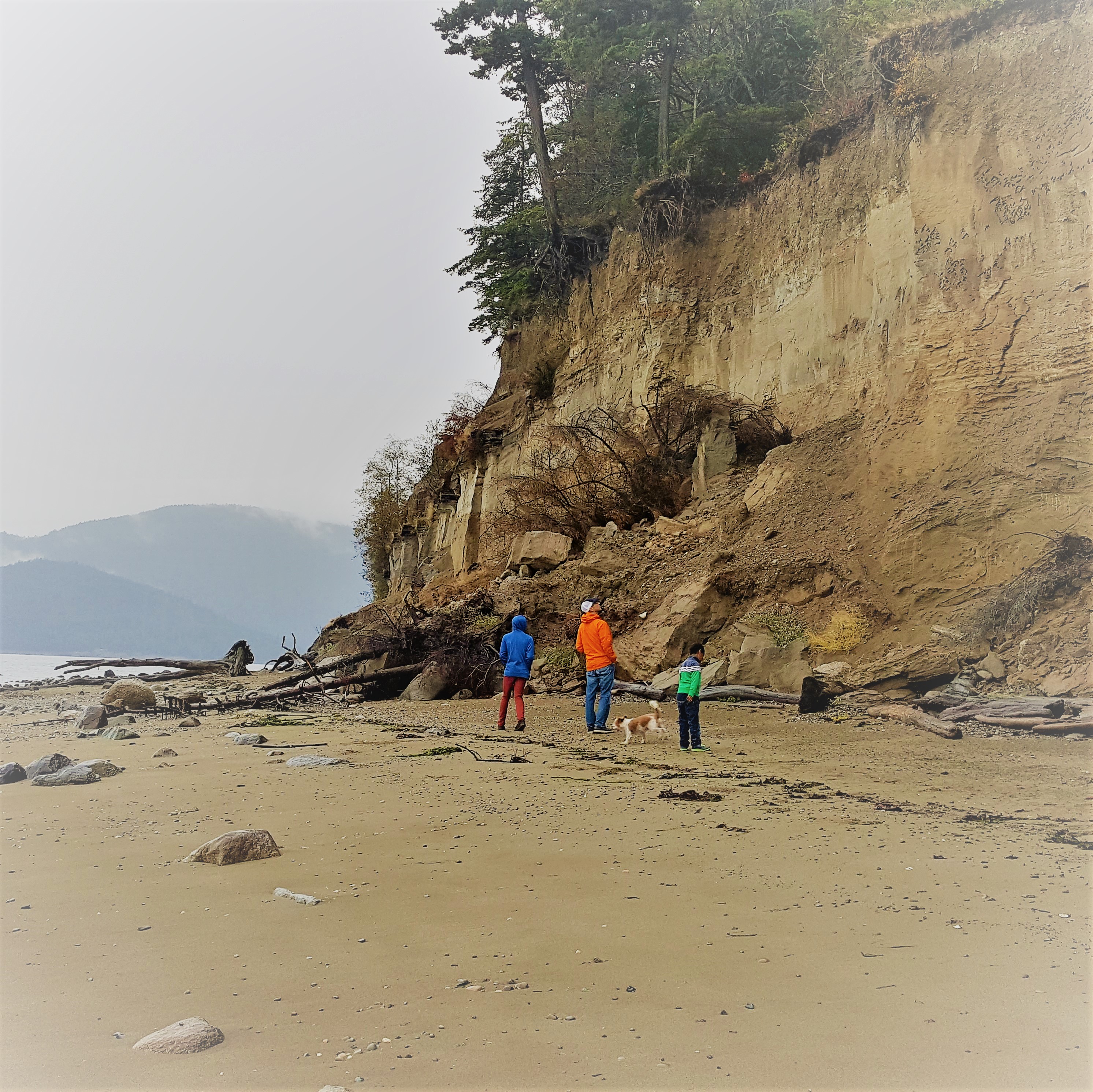
Above: Kelly's Point Conservation Area is a popular area to explore a stretch of undeveloped shoreline on Guemes Island. The beach is over a half mile long and the materials of Yellow Bluff contribute a considerable amount of sediment to nearby beaches and marine areas. Photograph credit: Skagit Land Trust staff.
Ecology
Kelly’s Point Conservation Area boasts ecological qualities that are increasingly rare in Puget Sound. It is one of only a few places left in the Pacific Northwest with a mature coastal forest along more than 3,000 feet of undeveloped marine shoreline. The immense cliffs of Yellow Bluff contribute an exceptional amount of sand and gravel to island beaches, including at the nearby Peach Preserve Wildlife Area. Kelly’s Point Conservation Area provides homes and nesting areas for countless bird species, including a colony of Pigeon Guillemots. The upland forest provides roosting, perching, and foraging habitat for a variety of raptors such as the Bald Eagle, Osprey, and Cooper’s Hawk, as well as migratory song birds.
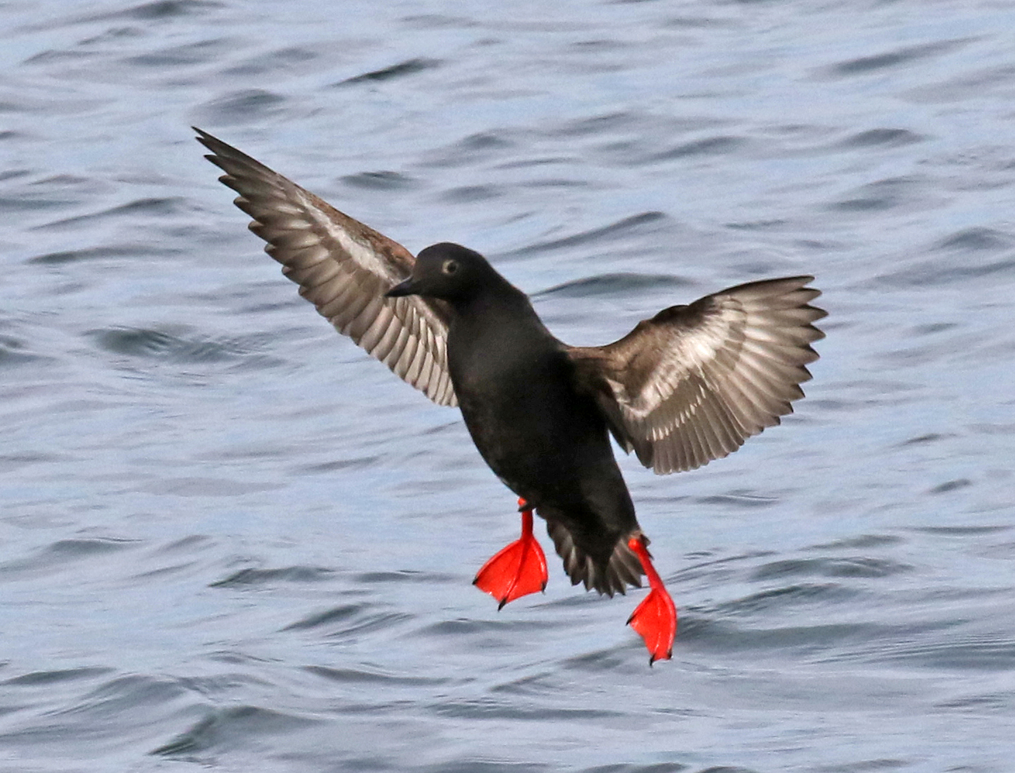
Above: Pigeon guillemots nest in the cliffs of Yellow Bluff at Kelly's Point Conservation Area. Photograph credit: Dennis Paulson.
Protection of Kelly’s Point Conservation Area maintains the rich wildlife habitat linkages between the island’s marine waters, bluff and forest. Kelly’s Point marks the western most edge of an open space corridor of conserved lands that is being knit together from Square Harbor to Yellow Bluff on Guemes Island. The upper bluff and forest are being managed as a wildlife sanctuary.
.jpg)
Above: Aerial map of land on Guemes Island that is under WA Coastal Wetlands Protection designation. Skagit Land Trust properties contribute to a wildlife and habitat corridor in the southern half of the island. Map generated by Skagit Land Trust staff (2017). Click on the map for a larger image.
Yellow Bluff at Kelly’s Point is classified by scientists as an “exceptional feeder bluff." Only 2% of Puget Sound shoreline meets the standards for this classification. Natural feeder bluffs such as those at Kelly’s Point play an unusually beneficial role in maintaining wildlife habitat and helping build and maintain Island beaches including at nearby Peach Preserve.
Geology
Kelly’s Point Conservation Area is a beloved outdoor classroom for studying geology. At Kelly's Point, Yellow Bluff exposes a remarkable sequence of sediments that span 70,000 years of Earth's history from before the last ice age, to about 13,000 years ago.
Above: Kelly's Point Conservation Area exposes sediments deposited by glaciers tens of thousands of years old along Yellow Bluff. Photograph credit: Skagit Land Trust staff.
Thick layers of glacial sediments underlie much of the northern Puget Lowland. These sediments were deposited between and during periods of ice sheet advance and retreat that occurred in Western Washington between 70,000 and 15,000 years ago. Yellow Bluff provides one of the best exposures of a sequence of glacial sediments from this period, providing a window into the past.
At the base of the bluff, the Whidbey Formation contains sediments that accumulated in the lowlands between 70,000 and 40,000 years ago. The Whidbey Formation includes sand, gravel, peat, volcanic ash, and organic sediments that accumulated during the period between two of the many ice age glaciations of Puget Sound.
The distinctive dark-grey peat layer was deposited on top of the Whidbey Formation is younger: 40,000 to 30,000 years old. Similar to the Whidbey Formation, these sediments were deposited during a period between the two ice age glaciations. Geologists call this time period the "Olympic interglacial interval." The peat and organic beds host a number of fossils that record the climate and environment of this period.
Overlying the peat layers are further glacial deposits that record the passage of the most recent ice sheet from Canada between 17,000 and 14,000 years ago. These layers include sand and gravel deposited by the advancing glacier. This layer is topped by a poorly sorted mixture of sand, silt, and rocks called “till” that is deposited beneath the glacier itself. At the top of Yellow Bluff is sediment that was deposited beneath the glacier as it retreated north and floated in the rising sea. Eventually the land rebounded from the weight of the ice and lifted these sediments above sea level to where they are now.
Click here for an annotated photograph detailing the age of sedimentary layers at Yellow Bluff.
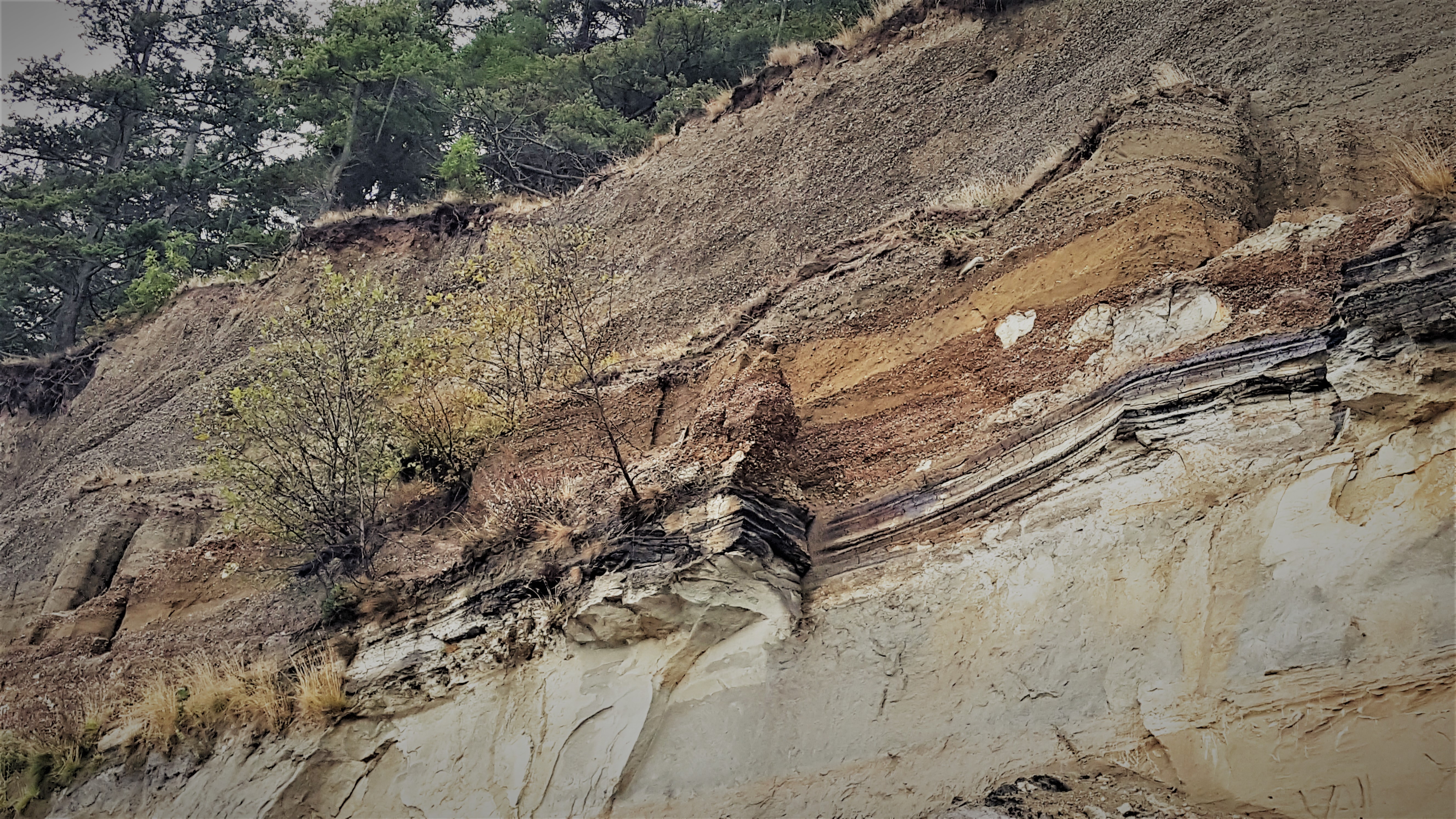
Above: Layers of sediment left by glaciers form high cliffs of Yellow Bluff at Kelly's Point Conservation Area. The dark grey layers are black because they contain the concentrated carbon-rich remains of plants from an ancient marsh. Photograph credit: Skagit Land Trust staff. Click on the photograph above for an enlarged image.
The work of stewarding such a diverse collection of properties is only possible through the help of dedicated volunteers. Click here to learn more about the land stewards for this and other Skagit Land Trust properties.
.JPG)
Access
The beach at Kelly's Point Conservation Area is open for low-impact, non-motorized use. The cliffs above the property are unstable and not safe to climb. We encourage you to visit the beach via a short access trail from the parking area.
.JPG)
Above: The beach at Kelly's Point Conservation Area is accessed via a short footpath from parking area on South Shore Road. Photograph credit: Skagit Land Trust staff.
Please keep in mind the following when visiting Kelly’s Point:
- Access to the beach is down a steep bluff using a pre-existing steep ramp. Use with caution and at your own risk! The access point may not be appropriate at this time for people with physical disabilities or for very young children.
- Similar to other natural areas, please keep your pet on a leash.
- Please do not build fires.
- UAVs or drones are prohibited.
- Please note that during high tide parts of the beach may become inaccessible making a return trip difficult and hazardous.
- The boundaries of Skagit Land Trust's conservation area are marked. The beach and uplands beyond these points are private. Please respect our neighbors' private property.
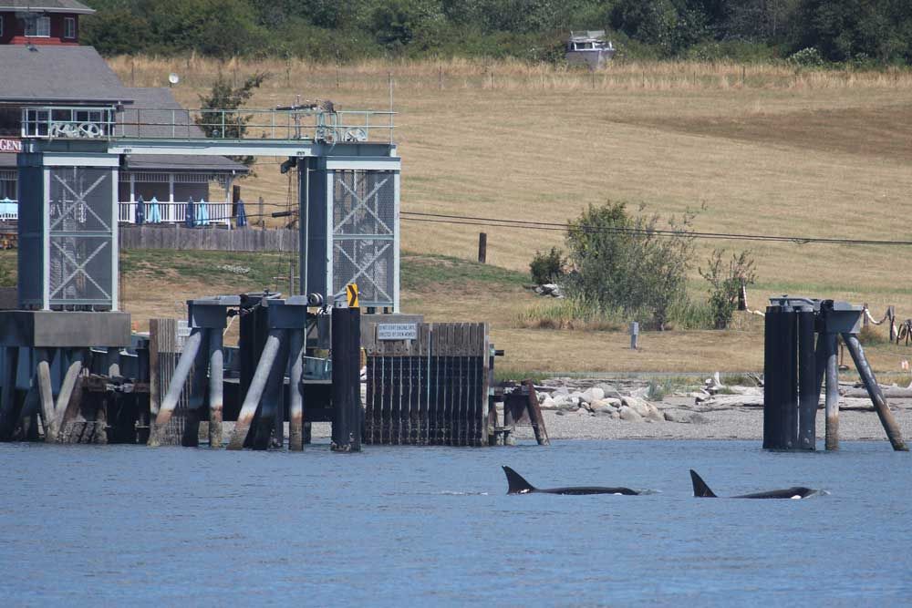
Above: Orca whales swim in front of the Guemes Island Ferry terminal. Photograph credit: Skagit Land Trust staff.
Click here for a link to Google maps for the Kelly's Point Conservation Area.
The Guemes Island General Store has a courtesy bike program, where visitors can ride the ferry and borrow one or two bikes to access the trailhead. Contact Guemes Island General Store at (360-293-4548) to reserve the bikes. Bathrooms are available where designated above on the map, at the Schoolhouse Park, the ferry terminal, and inside of the Guemes Island General Store fro customers of the store.
Click here for the Guemes Island Ferry schedule.
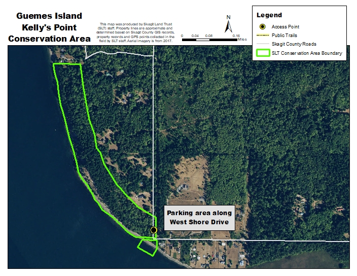
Click on the map above for an enlarged image. Map created using 2017 NAIP aerial imagery by Skagit Land Trust staff.
Take WA-20 west to Anacortes. Continue on WA-20 Spur west. Turn right on Commercial Avenue. Turn left at 12th street. Turn right at I Avenue. Board the Guemes Island/Anacortes Ferry.
Drive or bike north off of the Guemes Island Ferry several hundred feet and then take a left (west) on South Shore Drive. Follow South Shore Drive for approximately 1 mile. At the corner of South Shore Drive and West Shore Drive there is a parking area with trail access to beach.