The Tope Ryan Conservation Area property protects over 20 acres of former agricultural land including 900 feet of shoreline along the Samish River north of Burlington. The property also contains native riparian forest and several acres of pasture. This is a great property for wildflowers and bird watching. The property was donated to Skagit Land Trust in three stages in 1995,1996, and most recently in 2020.
.JPG)
Tope Ryan Conservation Area protect a mosaic of wetlands, streams, woodlands and pasture which provide habitat for a wide variety of fish and wildlife and a quiet setting for people. Photograph credit: Skagit Land Trust staff.
Conservation History
Tope Ryan is located within a rural area composed of homes, farms, and forestland. The Samish River runs along the west side of the property and the property is within the Samish floodplain. The Samish Ochs Conservation Area and the Koetje Conservation Area are to the northeast, also along the Samish River, and the Butler Creek Conservation Area is to the southwest, also in the Samish watershed. Anderson Mountain lies directly to the north.
The Tope Ryan Conservation Area was originally donated and accepted by Skagit Land Trust in order to preserve the mosaic of open field, riparian and forest habitat at the confluence of Swede Creek and the Samish River. Since the 1990s, the landscape on the property has changed dramatically. Beavers have engineered a dynamic wetland with riparian coverage, ponds, and natural large woody debris. The area is still a mosaic of habitat types with more wetland and less open fields, providing food and shelter for a wide variety of wildlife. The undeveloped lands at Tope Ryan Conservation Area help to improve water quality in the Samish River.
Ecology
Dominated by pasture when it was donated to the Trust, the property is becoming a forested wetland once again. Beaver channels connect Swede Creek, the unnamed creek, and the Samish River. Native plants have been installed in former fields over the years with mixed success. Most recently, in 2020 and 2021, large restoration plantings totalling over 5,000 plants were installed throughout the entire property, expanding the planted area into the former pasture and new portion of the property. Tope Ryan is part of the Samish River floodplain and includes 1700 feet along the Samish River.
Good salmon habitat features a non-hardened shoreline allowing for the natural meander of the river channel; a mixed stand of coniferous and deciduous vegetation, which provides cooling shade in the summer, stabilizes the soil to reduce sedimentation, and eventually serves as a source of large-woody debris for the channel. All of these features are present at this property.
Stewardship
Keeping the riparian area intact along the edge of the Samish helps improve water quality in a watershed that currently has many issues. In 2009, large woody debris (LWD) appeared after a flood event, significantly improving channel complexity. Swede Creek and the surrounding flooded area provide important habitat for amphibian reproduction, as well as beavers and a variety of fish species. Red legged frog and Northwestern salamander egg masses have been located in the streams during March/April amphibian surveys over the years. These areas and the riparian habitat along them have excellent complexity and diversity, increased by beaver activities. The riparian habitat is inhabited by a great variety of songbirds, small mammals, and amphibians. It captures sediment and provides a visual barrier between Gripp Road, surrounding fields and the open water, providing cover for deer, songbirds, and small mammals. Raccoon prints have been spotted by the waters' edge.
The woodland on the northeast side of the property provides additional diverse and protected forest habitat for wildlife and will likely eventually become a riparian edge if the field continues flooding. It contains a greater diversity of plant species than habitats elsewhere on the property, including multiple ferns, mosses and lichens, native flowers, woody shrubs and a variety of tree species. The peninsula on the north-west side of the property is less diverse than the woodland, but is still a healthy functioning riparian woodland with a varied ground layer, understory and canopy.
.JPG)
Stewardship of this property is only possible through the hard work of volunteers. Above: Community members participate in tree planting restoration project at Tope Ryan Conservation Area. Photograph credit: Skagit Land Trust staff.
Stewardship of this property is only possible through the hard work of volunteers. In the fall of 2019, volunteers and Skagit Land Trust staff completed a thinning project in the forested parts of the property. Old plantings that had a high survival of trees had become overgrown. This prevented the native understory species to establish. Additionally, because the trees were overcrowded, there was high competition for resources which was beginning to threaten the health of these trees. With the help of forestry experts and volunteers, Skagit Land Trust was able to remove some these trees, allowing the remaining ones to flourish.
%20.jpg) Removing some of the trees from the old, overcrowded plantings will promote a healthier forest overall.
Removing some of the trees from the old, overcrowded plantings will promote a healthier forest overall.
Click here to view information about the land stewards for this and other Skagit Land Trust properties.
Access
The Tope Ryan Conservation Area is located north of Sedro Woolley, just east of the intersection of Gripp Rd and Prairie Rd. There is a parking pullout with room for up to 5 cars on the south side of the property along Gripp Road.
Tope Ryan Conservation Area is open to the public and a great spot for birding. There are no established trails, but it is easy to walk through much of the planted area. The property can be very wet at times and visitors should watch out for deep, beaver created channels.
Click here for a link to Google Maps to the parking area at Tope Ryan Conservation Area.
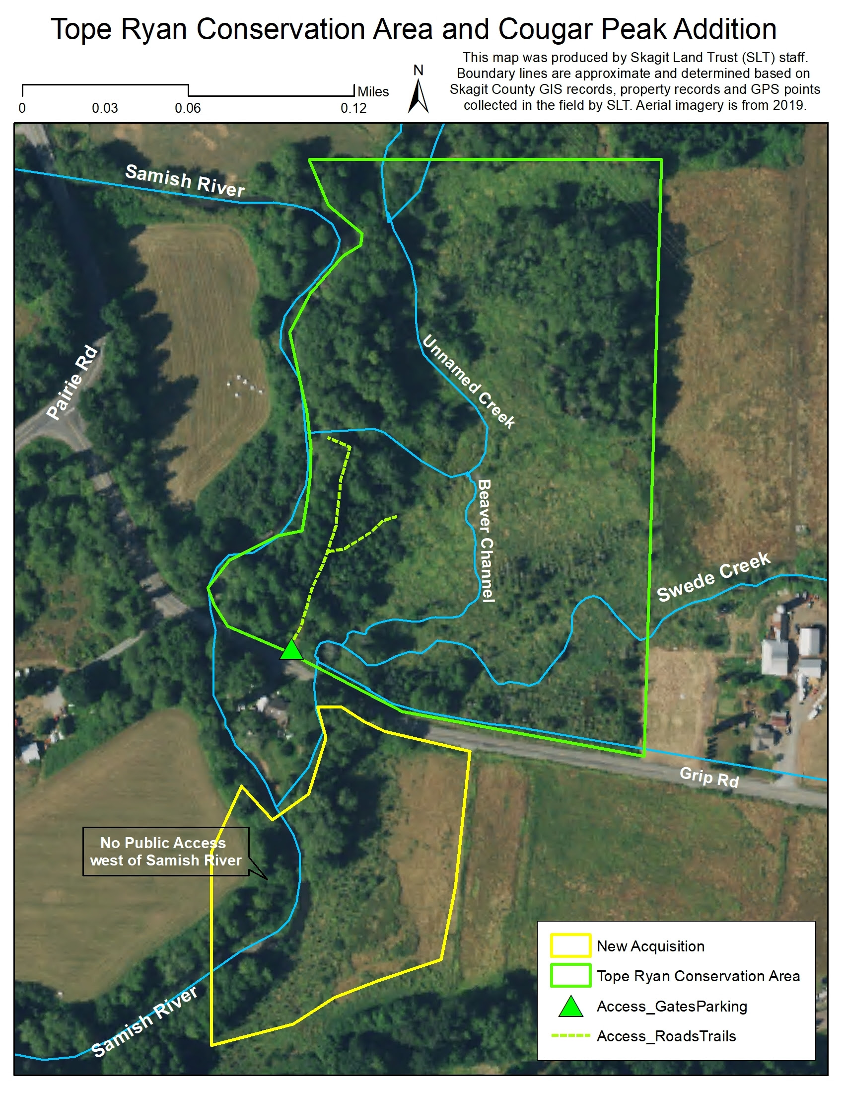
Map generated using 2019 NAIP aerial imagery.
From Mount Vernon take the I-5 Bow Hill exit #236 and go east on Bow Hill, continuing along it when it turns into Prairie Rd. Follow for about 3 miles. Turn right onto Grip Road. The property is the first driveway on the left, indicated by a Skagit Land Trust sign.